Hikes around Semmering
Hikes around
Semmering Hirschenkogel
Beautiful natural landscapes, stunning panoramic views, scenic hikes and a historic railway hiking trail to explore.
Hikes around Semmering
Enjoy the landscape
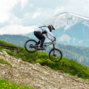
Semmering offers a diverse leisure experience in the Viennese Alps with its extensive hiking opportunities. Starting from the valley station of the cable car, visitors can explore various scenic trails that showcase the breathtaking beauty of the region.
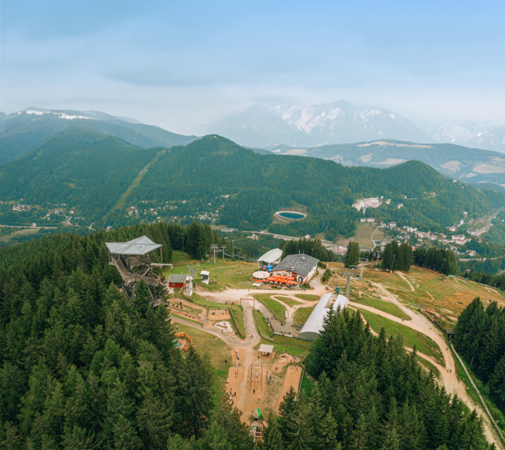
At the highest point of Hirschenkogel, the Millennium Observatory provides an unparalleled panoramic view of the Semmering-Rax-Schneeberg region, extending all the way to the Vienna Basin.
For a well-rounded experience, local mountain huts welcome hikers with a warm atmosphere and traditional culinary delights, ensuring a perfect mix of adventure and relaxation.


Lower Austrian
railway hiking trail
Starting from Semmering railway station, the trail follows the historic railway line, passing stunning viewpoints that offer panoramic views of this remarkable engineering masterpiece. Hikers can choose their own route, with options to reach Breitenstein (9 km), Klamm (15 km), Payerbach (21 km), or Gloggnitz (23 km) railway stations, making it easy to return to the starting point by train.
A highlights of the journey are the breathtaking viewpoints, providing unique perspectives of both the railway line and the beautiful Semmering region.At Semmering station, the new information center provides all the essential details about the Semmering Railway, a UNESCO World Heritage Site.

Styrian railway
hiking trail
The Styrian railway hiking trail is a hiking experience for the whole family. The Styrian Semmering Railway Hiking Trail is a themed hiking trail – Peter Rosegger accompanies the hikers and meets important contemporaries along the way. A short, informative cultural history of the Styrian Semmering is revealed along the way. The trail is around 17 km long and leads directly from Semmering railway station (connection to the railway hiking trail on the Lower Austrian side) onto the Hochstraße, along the old Reichsstraße, through the forests and meadows of Steinhaus and Spital am Semmering and via the Kulturbahnhof to Mürzzuschlag railway station.


Hiking routes
Distance: 7 km
Duration: 2 hours
Ascent/descent: 344 metres
Difficulty: easy
Starting point is the car park at the valley station of the cable car. Take the 3.5-kilometre forest road up to the summit of the Hirschenkogel. At 1,340 metres above sea level, you are rewarded for the ascent with a magnificent panoramic view from the Millennium Observatory. Before descending, the large sun terrace of the Liechtensteinhaus panorama restaurant invites you to linger.
Distance: 11.5 km
Duration: 4 hours
Ascent/descent: 703 hm
Difficulty: medium
The trail first leads along the road to the Sporthotel am Semmering. From here, head towards Maria Schutz until you reach the Sonnwendstein junction. Following the blue markings, you now climb the Sonnwendstein to the Pollereshütte. After a short ascent, you reach the Bergkircherl (1,523 m) – one of the most beautiful viewpoints in the Semmering region. The descent is via the Erzkogel summit cross (1,504 m) and the ridge path to the Brandstatt junction below the Hirschenkogel, then continue along the forest road (or comfortably by cable car) to the Enzianhütte and back to the pass summit.
Closed from August 29, 2025
Distance: 12.5 km
Duration: 4 hours
Ascent/descent: 770 hm
Difficulty: moderately difficult
The forest path takes you to Maria Schutz. The insider tip then leads steeply uphill from the fire station to the summit. The trail is part of the Gebirgsjäger memorial trail from the Pfaffensattel via the Sonnwendstein, Maria Schutz, Bärensattel, Eselstein, Kreuzberg and Payerbach to the Saurüssel. The trail is marked with a white edelweiss on a green background. For the way back, after a short descent to the crossroads, you can choose the Almsteig trail (blue markings). From here you return to the forest path.
Starting from the valley station of the cable car, you cross the top of the pass and find the start of this wonderful pond tour at the Happy Lift on the Panhanswiese. The trail then leads to the snowmaking pond at the Eisteichwiese and back to the top of the pass.